Department of Civil Engineering,Indian Institute of Science, Bangalore
In-situ testing for subsurface exploration and soil testing
Introduction
From historic times, characterization of subsurface has been playing an important role to assess the land uses nature, cause, and effect quickly and accurately for the human habitation and the living environment. The process of the estimating effects of earthquake in soil layers under earthquake loading requires understanding the properties of subsurface materials. The subsurface material characteristic is the key aspect affecting the applicability and feasibility of any project study in urban area.
The general site characterization need to provide the data related to site description, geological data, hydrogeologic data, aquifer characteristics, soil conditions and strength, risk assessment, presence and distribution of contaminants (if any). In the geotechnical engineering practice, the site characterization has to provide the detailed information about the mechanical and geometrical parameters of the subsurface, the effects of the proposed project on its environment and investigation of existing structures or lifelines below the subsurface. So that the data can be used to site selection, foundation and earthworks design, to study the effects of the earthquake. Here surface wave method and ground penetration radar has been presented with difference studies in earth science and civil engineering.
Ground Penetrating Radar for Civil/Geotechnical Engineering
The subsurface exploration and soil investigations are important part of civil/geotechnical engineering, where most of the designs are based on these results. Many field in-situ testing are practiced to determine the properties of subsurface materials. Conventional methods of boring, standard penetration tests and cone penetration tests provide information at a particular point, but spatial variation of geotechnical material and rock depth are essential for effective design of foundation and basement floors. Modern Ground Penetrating Radar (GPR) can be effectively used to map spatial variation of soil and rock layers with its thickness.
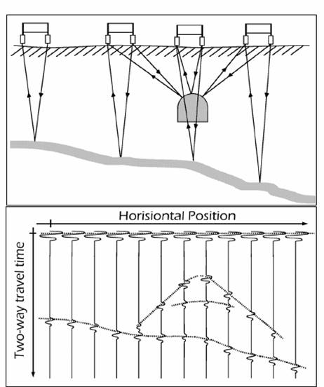
GPR is a geophysical technique to detect and identify structures, either natural or man-made, below the ground surface. GPR is a nondestructive method that produces a continuous cross-sectional profile or record of subsurface features, without drilling, probing, or digging. GPR profiles are used for evaluating the location and depth of buried objects and to investigate the presence and continuity of natural subsurface conditions and features. GPR is a nondestructive and environmentally safe method to detect, locate and map the subsurface features. The fundamental principle of operation is the same as that used to detect aircraft overhead, but in GPR the antennas are moved over the surface rather than rotating about a fixed point.
Radar is the short form for RAdio Detection And Ranging, so it's quite clear what it is all about: detection of a target and determination of its distance from the radar antenna. In general radar systems determine not only the distance but also the direction or location of the target. Both conventional radars and GPR use the same principle of traveling and reflection of electromagnetic waves although the ways in which the waves are generated and treated are completely different. A radar pulse is emitted by the transmitter antenna is partly reflected and partly transmitted when it meets with an electrical discontinuity in the ground, that is an interface at which there are a change in electromagnetic wave impedance or in other words a change in electrical properties. If the time for the pulse to go to the reflector and get back again to the receiver antenna is measured, the location of the reflector in the ground can be decided, if the velocity of the pulse is known. It can be clearly seen from the Figure the interfaces as layers resulting in a layer in the radargram, whereas objects in the form of hyperbolas.
Soil And Rock Depth Mapping Using GPR
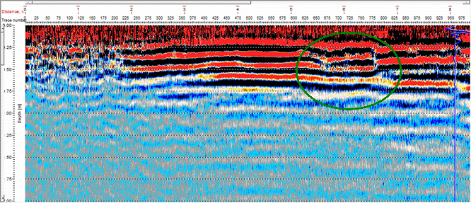
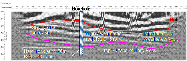
Ground Penetration Radar(GPR) is the most useful technique for shallow workings even though it has some limitations (Olhoeft, 1984). Compared with other geophysical tools, GPR is proving to be an effective instrument for exploring earthen materials (Doolittle and Collins, 1995). The use of GPR in soil survey investigations was first demonstrated in Florida by Benson and Glaccum (1979); Johnson et al. (1980) and Doolittle and Collins, (1995). Doolittle and Collins, (1995) used GPR to study soil characteristics, taxonomic composition, and variability within the map units and highlighted that GPR provided accurate and detailed information for the above applications. Conventional way of determining rock depth is inadequate to map bedrock for foundation and basement floor design, seismic site classification, site response and microzonation. The study has been carried out by Dr. Anbazhagan and his research team to profile the subsurface using GPR and compared with the drilled borehole data. Ground coupled 25 MHz and 500 MHz GPR antennas were used close to boreholes and electromagnetic wave forms were recorded. Radar data collected from each location was processed. Radargram for each was obtained after removal of noise by processing the data. Changes in the wave form and contracts of image are used to draw depth of the each layer. Figure shows the typical subsurface GPR profile of Coimbatore site. It is noticed that the thickness of soil layers and depth of rock obtained from GPR is matches very well with the borehole. It can be observed from the Figure that soil thickness varies spatially, it is very difficult to capture this information in any other subsurface exploration techniques. Rock depth and soil type variation can be captured very accurately in the shallow bedrock region. Rock depth plays a very important role in seismic site classification. In this contrast, evaluating soil thickness and rock depth using GPR is very important. GPR wave form can also be used to estimate dielectric constant of materials and this can be further used to relate the different type of soils.
Quality of Compaction/ Homogeneity of Subsurface
Filling of soil and compaction is a routine activity in construction industries. Poor or heterogenic compaction leads to sever settlements and cracks during or after completion of the project. Presently no unique method is available to check the uniformity of compacted soil and thickness after covering the compacted materials. Dr. Anbazhagan and his research team have carried out GPR survey on finished floor to detect the compaction quality below the floor slab. Initially GPR is calibrated to capture required depth and information by carrying out few trial surveys. Trial survey shows that signal was obtained for penetration depth of 2.5 m to 5 m. Average depth was fixed as 3.5 m from ground surface. The study area was divided into number of grids and survey has been carried out in each grid line to capture two and three dimensional variations. Analysis of GPR Radargram shows that materials below floor slab is not uniform (see Figure). The heterogeneity in the soil profile starts from about 0.5 m to 1 m below floor level and noticed up to 3 m.